

The Brahmaputra, one of the largest rivers of the world, originates from Chemayungdung glacier of Kailash range near Manasarovar Lake in Tibet.
In Tibet, Brahmaputra river called Tsangpo means the purifier. The Rango Tsangpo is a major right bank tributary of Tsangpo river in Tibet. In China, it is known as Yarlung Zangbo.
Mariam La seperates Brahmaputra from Manasarovar Lake.
It emerges as a turbulent and dynamic river after carving out a deep gorge in the central Himalayas near Namcha Barwa.
The river emerges from the foothills under the name Dihang or Siang. It enters India west of Sadiya Town in Arunachal Pradesh.
Flowing southwest, it receives its main left bank tributaries viz., Dibang or Sikang and Lohit; thereafter, it is known as the Brahamaputra.
Several islands are found in the path of this river. Majuli is the world’s biggest riverine island.
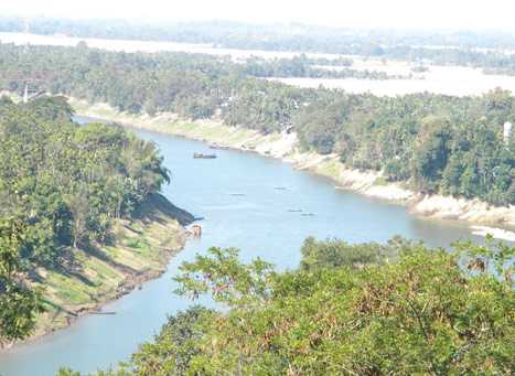
It enters Bangladesh near Dhubri and flows southward. The Brahmaputra receives numerous tributaries in its 750 km long journey through the Assam Valley. The catchment area of the Brahmaputra receives heavy rainfall.
Most of the tributaries are large and pour large quantity of water and sentiment into the Brahmaputra river. During the rainy season, the river oscillates from one bank to other for a width of 10 km, and being turbulent with loads of silt, the channel is heavily braided.
There is a constant silt movement resulting in the instability of regime, channel shifting and formation of sandy shoals. Majuli is the largest river island in Asia, lies in this river which is bounded by the Lakhimpur District in the north and the Jorhat District in the south.
The Brahmaputra river basin is notorious for flooding and river bank erosion. The floods affect on average , an area of 100,000 hectares annually. The peak annual discharge at Pandu, near Guwahati, is more than 2.5 million cusecs, while the low discharge is 120,000 cusecs.
Left bank tributaries :- Burhi-Dihang, Dhansiri, Lohit and Kalang.
Right bank tributaries :- Subansiri, Kameng, Manas, Teesta and Sankosh.
Tributaries of Brahmaputra River

The Manas River

It is a transboundary river in the Himalayan foothills between southern Bhutan and India. The river flows through Bhutan in a southwest direction between two ranges of the lower Himalayas in a V-shaped gorge and enters into Assam, India into the south-central foothills of the Himalayas. It is an antecedent river and joins Brahmaputra. Rising from Tibet, it pierces the Greater Himalayas in a gorge with a river bed at 3000 m. It collects a number of tributaries in the Lesser Himalayas and debouches into the plains to join the river Brahmaputra.
The Teesta River

It is the western most right bank tributary of Brahmaputra. It originates from Kanchenjunga and joins Brahmaputra in Bangladesh. This river also forms a deep gorge in Darjeeling hills. It’s important tributaries are Rangpo, Rangit and Sevak. Teesta is a 414 km long river flowing through the India’s states of West Bengal and Sikkim before reaching Bay of Bengal through Bangladesh. It is the fourth largest transboundary river shared between India and Bangladesh after Ganga, Brahmaputra and Meghna river systems.
The Sankosh River

This is the main river of Bhutan. It meets Brahmaputra river below Dhubri. The sankosh river forms the boundary between Assam and Arunachal Pradesh. It is known as ‘Puna Tsang Chu’ in Bhutan. It originates from northern Bhutan making border-between Assam West Bengal. This river joins Brahmaputra near Assam-Bangladesh border.
The Rangit River

`Originating from Sikkim, Rangit river has a large number of rapids. This river is well known all over the world for rafting sports. Its banks provide good camping grounds. Rangit river is globally famous for water-sports such as rafting.
The Subansiri River

This is a large tributary of the Brahmaputra river. It has a long course in the Himalayas and, after leaving the mountains, it has a long 160 km course in the Upper Assam Plain before joining the Brahmaputra. It separates the Miri Hills from the Abor Hills. It originates in Tibet and it is an antecedent river. It joins Brahmaputra near Lakhimpur. It is the largest tributary of Brahmaputra.
The Dhansiri River

This river Originates from Laisang Hills in Nagaland and after flowing for about 300 km through Nagaon, it joins the Brahmaputra river.
The Kaladan River

It flows in southern parts of Manipur and Mizoram drains into Bay of Bengal. A hydro-electric project is located on this river.
The Manipur River
It rises from the northern part of Manipur and flows southwards. On passing through Imphal, this river drains the Loktak Lake and joins the Chindwin Valley, a tributary of the River Irrawaddy in Myanmar (Burma).
The Barak River

This river rises from Mt. Japov (Nagaland), flows southwards in Manipur and makes a hair pin bend. Several of its affluents, which drain the northern part of Mizoram, combine together to flow past Silcher in the Cachar District. The Barak basin has Mawsynram and Cherrapunji which recieve the highest rainfall in the world. Consequently, the Barak river meets the Padma at Chandpur below Dacca, after which the combined river of Surma (Barak) and Padma is known as Meghna.
Various Name of Brahamputra
India – Brahmaputra
Tibet – Tsangpo
China – Yarlung Zongbo
Bangladesh – Jamuna
